Research & Planning
Strategic Project Charter
An Engineering-Grade Framework for Predictive Water Management
Mission
Project Objectives
1. Predictive Modeling
Simulate nutrient flux (Phosphorus/Nitrogen) based on high-resolution rainfall events. Forecast Trophic State changes to provide early warnings for harmful algae blooms.
2. Decision Support
Provide a 'Virtual Jar Test' environment for chemical treatment validation before deployment. Optimize municipal and agricultural planning through lakeshore capacity assessment.
3. Automated Inspection
Perform continuous auto-checks on weather forecasts, volunteer field data, and satellite inputs. Automatically trigger human-in-the-loop inspections and AI-generated field briefs.
Workflow
Operational Workflow
Methodology: A continuous early-warning loop combining physical simulation, satellite remote sensing, and citizen science validation.
📡 1. Baseline Ingestion
🌤️ 2. Weather Scenarios
📍 3. Volunteer Ground-Truth
🚨 4. Alert & Dispatch
The system begins by establishing a high-resolution spatial and structural foundation for each water body:
- Bathymetry Mesh: Building 3D volumetric models to track storage capacity and hypoxic zones.
- Satellite Remote Sensing: Continuous ingestion of Sentinel-2 L2A multispectral bands:
NDWI / MNDWI
Water Index Mask
Isolates water surface area boundaries to mask out land cover.
NDCI
Chlorophyll Proxy
Highlights chlorophyll concentration to spot surface algae bloom activity.
NDTI
Turbidity Proxy
Maps suspended mineral and organic sediment concentration spreads.
Documentation
Project Documentation
1. Project Vision
To develop a predictive "Living Digital Twin" of Ontario's inland lakes that treats the water body as a biological system (metabolism). The goal is to move from reactive monitoring to predictive intervention using real-time environmental transients and remote sensing.
2. Core Engineering Logic (Mass Balance)
The system operates on the principle of Accumulation = Input - Output ± Reaction.
- Inputs: Rainfall intensity, agricultural phosphorus loading.
- Outputs: Hydraulic flushing (residence time) and sediment burial.
- Reaction: Chemical precipitation (Virtual Jar Test) based on the Calcium:Phosphorus ratio.
- Triggers: Rules checking rain (>45mm), temperature gradient (>1.5°C), and satellite NDCI anomaly spikes.
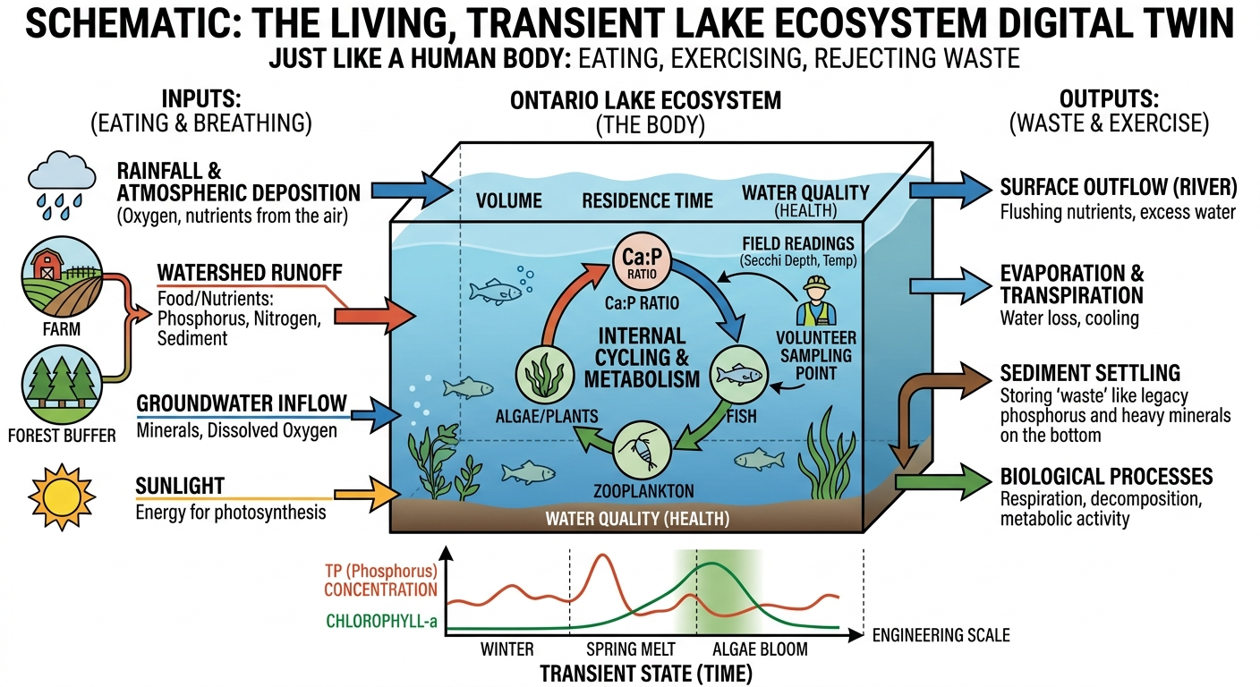
Project Schematic: Lake Metabolism Model
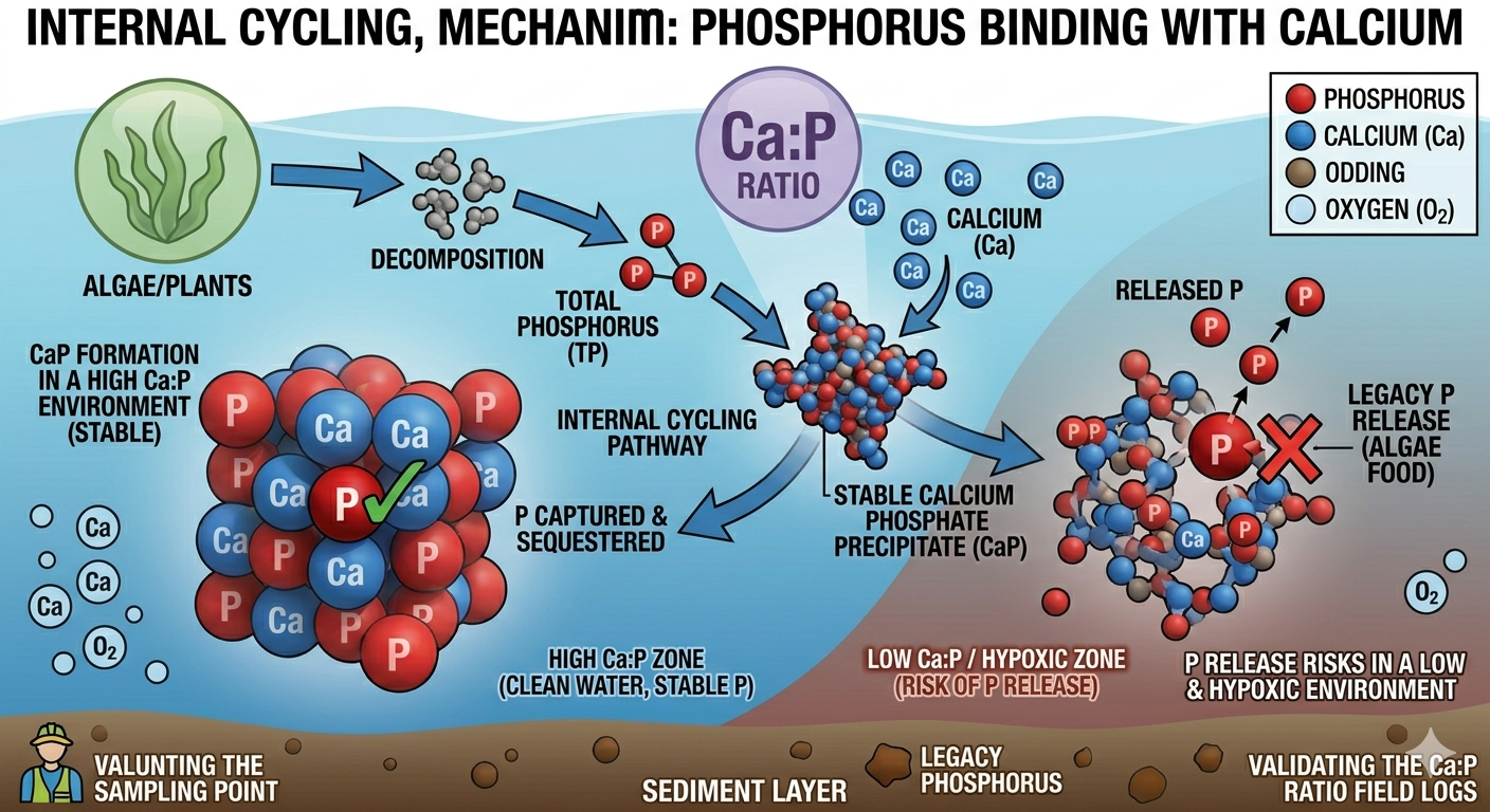
Chemical Process: Calcium-Phosphorus Reaction
3. Current Technical Stack
- UI Framework: Next.js + React (Modern Web Front)
- Computation: Streamlit (Limnological Simulation Engine)
- Geospatial: WhiteboxTools (Catchment & Bathymetry)
- Alerts & AI: Rule engines integrated with Gemini API briefings
4. Key Components
- Virtual Jar Test: Simulator for chemical dosing (Lime/Calcium) predicting phosphorus removal.
- 3D Bathymetry: Dynamic mesh to visualize hypoxia and thermocline stratification.
- Sentinel Alert: Real-time trigger evaluation and dispatch briefs.
5. Roadmap & Milestones
- ✔ Early warning thresholds
- ✔ Gemini API automated briefs
- Connect live MSC Weather API
- Import LPP historical databases
Aligned with CCMEGuidance for Water Quality Monitoring & Ontario handbook.
Confidential Presentation - Preliminary Engineering Design